After more than 2 months of development we are happy to announce that v4.3 is finally available.
Thanks to our new code base since version 4.0 we were able to easily add new features which have been requested for a long time, like support for drawing polylines directly on maps. In addition we also added lots of minor optimizations and bugfixes in order to fulfill our vision to provide the most comprehensive and usable mapping plugin for WordPress.
An update to the latest version is – as always – highly recommended.
So let´s now get to the highlights of v4.3:
 We enhanced Maps Marker Pro with the fabulous leaflet library leaflet.pm maintained by Sumit Kumar, who is also providing https://geoman.io which allows its customers to manage geospatial data with a visual toolbox and powerful APIs. Check out Geoman and consider subscribing to the Leaflet.PM supporter plan if you want to support development of advanced leaflet.pm features – this will also get you prioritized support and consultation from Sumit.
Anyway as said before, we use leaflet.pm as basis in Maps Marker Pro in order to provide you with the ability to draw, edit, drag and cut geometry layers like polylines, polygons, circles and rectangles directly on your maps:
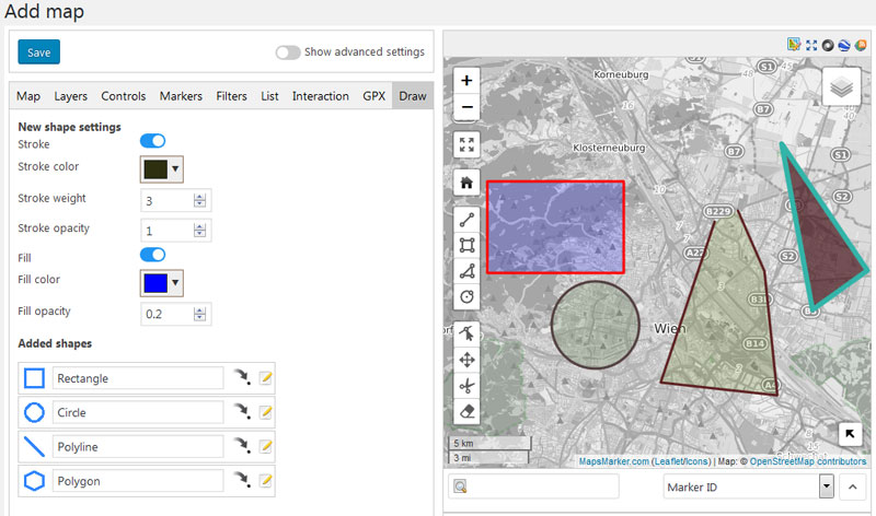
Please see the following animation on how polylines can be edited (animation with courtesy of Sumit Kunar – just be aware that the marker adding functionality as seen in the animation is not supported in Maps Marker Pro – if you want to add a marker, please use the “add marker” feature):

We hope you like this new feature as much as we do – if you find any issues, please let us know!
Although Gutenberg has been available since WordPress 5.0, we waited until now to add a dedicated map block, as there were lots of bugs which prevented the proper usage yet. Although Gutenberg still has lots of negative critics and needs improvements in many areas like accessibility, we decided to add a basic block for easily adding maps. Anyway please be aware that you can also still use the shortcode block in Gutenberg to add map shortcodes.
Block selection:
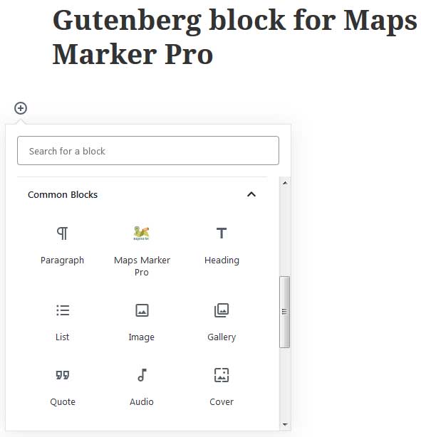
View after block and map is selected:

On the list of markers page on backend we added a new dropdown which allows you to only show markers from a specific map:

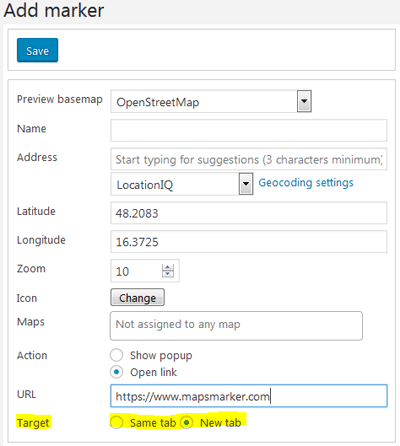
For markers we added an option which allows you to specifiy the link target if you choose to show a link instead of a popup for a marker:
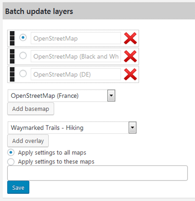
We also enhanced the tools section with v4.3, now allowing you to batch update the available layers for all or selected maps only:
With v4.3 it is now also possible to highlight a specific marker not just on fullscreen maps but also on maps embedded in regular posts. So in order to center the map on the marker and open its popup, just add the URL parameter ?marker= and the ID of the marker to the URL where the map is embedded.
Example: https://www.mydomain.com/link-to-post/?marker=9
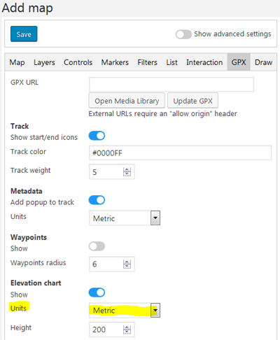
For GPX elevation charts you can now also set the units to use (metric or imperial):
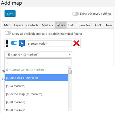
If you are managing a larger number of maps, it is now easier to find the map you want to add to a filter, as we added search support for the filter dropdown:
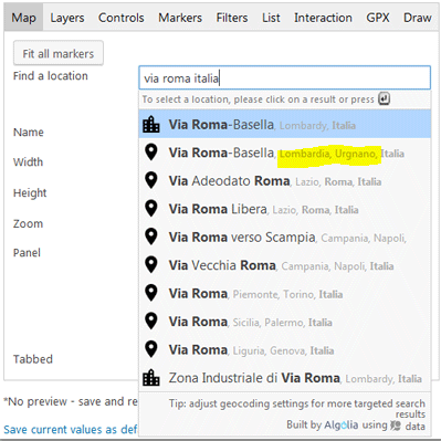
The quality of the geocoding results for the providers Algolia, Photon and locationIQ has also been improved with v4.3: you now also see the postcode and city of the results. Anyway please be aware, that those data might not be available everywhere, depending on the quality of the geocoding provider´s data:
An important bugfix also made it into v4.3: with WordPress 5.0.1 changes in MIME type validations were introduced, which also resulted in GPX uploads failing in Maps Marker Pro, which could only be fixed by allowing unfiltered uploads (see FAQ).
We actually hoped for WordPress to provide a quick fix here, unfortunately the related tickets have been postponed from 5.1 to 5.2 and now to 5.3, which is why we searched and finally found a fix for this issue which is unrelated to a possible fix provided by WordPress.
GPX uploads should now work again as usual – if you allowed unfiltered uploads because of this issue on your site, it is recommended to disallow those unfiltered uploads again by removing the related code from your wp-config.php accordingly.
To update all GPX files which have been uploaded with unfiltered uploads enable to use the proper mimetype, please execute the following SQL statement directly via phpmyadmin for example: UPDATE `wp_posts` SET `post_mime_type` = 'application/gpx+xml' WHERE `post_type` = 'attachment' AND `guid` LIKE '%.gpx'; (if you are using a custom database prefix, please change wp_ accordingly). If this is not done, GPX files will not show up when opening the media library with v4.3 and have to be re-uploaded as workaround.
Changelog for version 4.3 - released on 04.05.2019 (release notes)
 | polyline support: draw and edit geometry layers directly on your maps | |
 | map block for Gutenberg editor | |
 | add map filter for list of markers page | |
 | add target option for marker links | |
 | add batch update layers tool | |
 | add marker highlight functionality for non-fullscreen URLs | |
 | add option to change units for elevation chart tooltip | |
 | add filter dropdown search for maps | |
 | show postcode & city in Algolia, Photon & locationIQ geocoding result previews (if available) | |
 | updated PUC (plugin update checker) to v4.6 including optimizations & compatibility fixes (thx Yahnis!) | |
 | latest WPML string translation integration was broken | |
 | fix long URLs for custom layers not being saved | |
 | incomplete KML export (wrap title and popup in CDATA) | |
 | license distribution tool to subsites on WordPress multisites was broken | |
 | fix conversion to imperial for elevation in GPX meta popup | |
 | add workaround for mime type issue (since Wordpress 5.0.1) when uploading GPX files | |
 | prevent Yoast SEO plugin to overwrite title-tag on fullscreen maps with homepage title | |
 | updated Chinese translation thanks to John Shen and ck | → contribute |
 | updated Dutch translation thanks to Ronald Smeets, Marijke Metz, Patrick Ruers, Fokko van der Leest and Hans Temming | → contribute |
 | updated German translation by Maps Marker Pro team and Daniel Luttermann | → contribute |
 | updated French translation thanks to Vincèn Pujol, Rodolphe Quiedeville, Fx Benard, Cazal Cédric, Fabian Hurelle and Thomas Guignard | → contribute |
 | updated Italian translation thanks to Luca Barbetti and Angelo Giammarresi | → contribute |
 | updated Japanese translations thanks to Shu Higash and Taisuke Shimamoto | → contribute |
 | updated Russian translation thanks to Ekaterina Golubina (supported by Teplitsa of Social Technologies - http://te-st.ru) and Vyacheslav Strenadko, http://slavblog.ru | → contribute |
 | updated Swedish translation thanks to Olof Odier, Tedy Warsitha, Dan Paulsson, Elger Lindgren, Anton Andreasson and Tony Lygnersjö | → contribute |
If you experience any issues, please search our knowledge base or submit a helpdesk ticket.
Happy mapping!
The recommended way to update is to use the WordPress update process: login with an user who has admin privileges, navigate to Dashboard / Updates, select plugins to update and press the button “Update Plugins”. The pro plugin checks every 24 hours if a new version is available. You can also manually trigger the update check by going to Plugins and clicking on the link “Check for updates” next to “Maps Marker Pro”.
If there is an update available, please start the update by clicking the link “update now”.

If you try to update from v3.1.1 or lower, please see this user guide in our knowledge base for installation instruction and a migration tutorial.
No additional actions are required for beta testers when updating to this version.
v4.3 includes the following relevant changes to the database tables:
geojson TEXTblank INT(1)If your custom application based on the Database API is processing requests for maps or markers, please make sure to also include those new fields.
For the next release we plan to optimize the Database API in general and the related docs so that using it becomes easier.
For directly downloading and installing the Maps Marker Pro as zip file, please click here.
For the SHA-256 hash value and the number of files for this release please check the following file: https://www.mapsmarker.com/SHA256SUMS.txt
This file is digitally signed with our PGP key, key signature file available at https://www.mapsmarker.com/SHA256SUMS.txt.sig
Click here for a tutorial on how to verify the integrity of the plugin package (recommended if the plugin package for a new installation was not downloaded from https://www.mapsmarker.com – verification is not needed though if the automatic update process is used).
Let us know what you think about this new release by submitting a review or leaving a comment below!
If you want to keep up to date with the latest Maps Marker Pro development, please follow @MapsMarker on twitter (= most current updates) or on Facebook, subscribe to news via RSS or via RSS/email.
We would also like to invite you to join our affiliate program which offers commissions up to 50%. If you are interested in becoming a reseller, please visit https://www.mapsmarker.com/reseller