“No pain, no gain” – this has been definitely true for this release and I am sure it has been worth it 🙂 Actually I would have been finished earlier if there were no Internet Explorer out there anymore (at least v8 😉 ).
If you want to keep up to date with the latest Maps Marker development, please follow @MapsMarker on twitter, on Facebook, Google+ or subscribe to news via RSS or via RSS/email.
Now let´s get to the highlights of pro v1.2:
With pro v1.2 it is now possible to display GPX tracks together with optional metadata on maps:
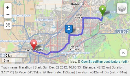
For a live demo please visit http://demo.mapsmarker.com/.
The original GPX plugin for leaflet was developed by Pavel Shramov – anyway I used the fork from Maxime Petazzoni as a basis for Leaflet Maps Marker Pro. Unfortunately I also had to fork the GPX plugin in order to fix Internet Explorer issues and overcome cross-domain restrictions (I sent the changes to Maxime who might possibly integrate them into his fork too).
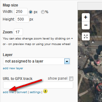
A gpx track can be added on marker and layer maps – just click on the link “add files” in the new GPX section:
As next step, upload your .GPX file and click on the button “Insert GPX track” – the track gets loaded instantly afterwards:
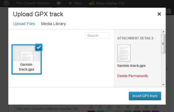
If you want to load a GPX track from an external domain, just enter the URL into the field “URL to GPX track”.
If your GPS device does not support the export as .GPX file, please follow these instructions on how to convert your track to .GPX.
By default, the metadata panel (with time, distance etc) gets displayed when a new track is added.
As always you can set general GPX track options in Settings / Map Defaults / GPX track settings:

For a later pro release I also plan to add an elevation chart.
If you are a developer using Leaflet Maps Marker Pro for your clients, you might be interested in this new feature, which can be found in Settings / Misc.
Set this feature enabled if you want to remove all backlinks and logos on backend as well as making the pages and menu entries for Tools, Settings, Support, License visible to admins only (user capability activate_plugins):
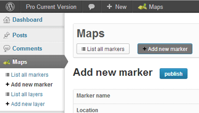
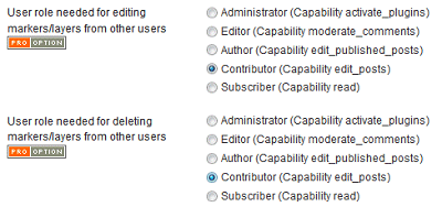
I also enhanced the permission settings with Leaflet Maps Marker Pro v1.2: you are now able to set the user level needed for editing and deleting markers and layers from other users.
By default, these settings are disabled respectively set to the same user level which is needed for editing and deleting one´s own markers and layers. Setting them to “Administrator” for example , allows non-admin-users to only edit or delete their own markers and layers.
These new settings can be found in Settings / Misc:
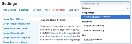
The settings page is a central part of Leaflet Maps Marker Pro, allowing you to customize many aspect of how your map is displayed.
Since the launch of the first free version about 18 months ago, the number of available options grew larger and larger, making finding the right option harder.
This is why I am now quite happy now that thanks with the help from Yakir Sitbon I could implement the following improvements of the settings page:
Thanks to many motivated contributors, pro v1.2 comes with the following translation updates:
New translations
Updated translations
If you want to contribute to translations (Persian would be great 😉 ), please visit http://translate.mapsmarker.com/projects/lmm for more information.
The following issues are still open and I will do my best to fix them with the next release:
As next step I plan to launch the affiliate program which allows you to receive a commission on each sale that is made from a user who first visited mapsmarker.com through a link on your site for example. Details will follow soon in a separate blog post.
Please also see the roadmap for a rough schedule for planned features and please subscribe to this blog (via RSS or Email) or follow @MapsMarker on twitter if you want to stay up to date with the latest development news.
| support for displaying GPX tracks on marker and layer maps | |
| option to whitelabel backend admin pages | |
| advanced permission settings | |
| optimized settings page (added direct links, return to last seen page after saving and full-text-search) | |
| removed visualead logo and backlink from QR code output pages | |
| changed minimum required WordPress version from v3.0 to v3.3 (needed for tracks) | |
| increased database field for multi layer maps from 255 to 4000 (allowing you to add more layers to a multi layer map) | |
| optimized marker and layer edit page (widened first column to better fit different browsers) | |
| allow custom icon upload only if user has the capability upload_files | |
| optimized default backlinks and added QR-link to visualead | |
| reduced maximum zoom level for bing maps to 19 as 21 is not supported worldwide | |
| API does not break anymore if parameter type is not set to json or xml | |
| marker icons in widgets were not aligned correctly on IE<9 on some themes | |
| javascript errors on backend pages when clicking “show more” links | |
| Using W3 Total Cache >=v0.9.3 with active CDN no longer requires custom config | |
| wrong image url on on backend edit pages resulting in 404 http request | |
| wrong css url on on tools page resulting in 404 http request | |
| plugin install failed if php_uname() had been disabled for security reasons (thx Stefan!) | |
| Wikitude API was broken when multiple multi-layer-maps were selected | |
| broken settings page when other plugins enqueued jQueryUI on all admin pages | |
| undefined index error messages on recent marker widget with debug enabled | |
| Translation updates In case you want to help with translations, please visit the web-based translation plattform |
|
| Spanish/Mexico translation thanks to Victor Guevera, http://1sistemas.net | |
| updated Catalan translation thanks to Efraim Bayarri, http://replicantsfactory.com and Vicent Cubells, http://vcubells.net | |
| updated Chinese translation thanks to John Shen, http://www.synyan.net and ck | |
| updated Croatian translation thanks to Neven Pausic, http://www.airsoft-hrvatska.com, Alan Benic and Marijan Rajic, http://www.proprint.hr | |
| updated Czech translation thanks to Viktor Kleiner and Vlad Kuzba, http://kuzbici.eu | |
| updated Dutch translation thanks to Patrick Ruers, http://www.stationskwartiersittard.nl | |
| updated German translation | |
| updated French translation thanks to Vincèn Pujol, http://www.skivr.com and Rodolphe Quiedeville, http://rodolphe.quiedeville.org, Fx Benard, http://wp-translator.com and cazal cédric, http://www.cedric-cazal.com | |
| updated Italian translation thanks to Luca Barbetti, http://twitter.com/okibone | |
| updated Latvian translation thanks to Juris Orlovs, http://lbpa.lv and Eriks Remess http://geekli.st/Eriks | |
| updated Romanian translation thanks to Arian, http://administrare-cantine.ro and Daniel Codrea, http://www.inadcod.com | |
| updated Spanish translation thanks to Alvaro Lara, http://www.alvarolara.com and http://www.labviteri.com | |
| updated Ukrainian translation thanks to Andrexj, http://all3d.com.ua | |
| Known issues Although we tried hard, not all known issues could be fixed with this release: |
|
| Google Adsense ads are not clickable on layer maps | |
| maps break if the option worldCopyJump is set to true (false by default in settings / map defaults / interaction options) | |
The easiest way to update is to use the WordPress update process: login with an user who has admin privileges, navigate to Dashboard / Updates, select plugins to update and press the button “Update Plugins”.
The pro plugin checks every 12 hours if a new version is available. You can also manually trigger the update check by going to Plugins and clicking on the link “Manually check for updates” next to “Leaflet Maps Marker Pro”:

If you upgrade from v1.2-beta1 or v1.2-RC1 please clear your browser cache once manually as otherwise the display of the settings page will be messed up.